
Two maps Wounded Knee Massacre and Drexel Mission Fight
Two maps Wounded Knee Massacre and Drexel Mission Fight
Two maps Wounded Knee Massacre and Drexel Mission Fight
Two maps relating to the Wounded Knee Massacre and the Drexel Mission Fight VG+
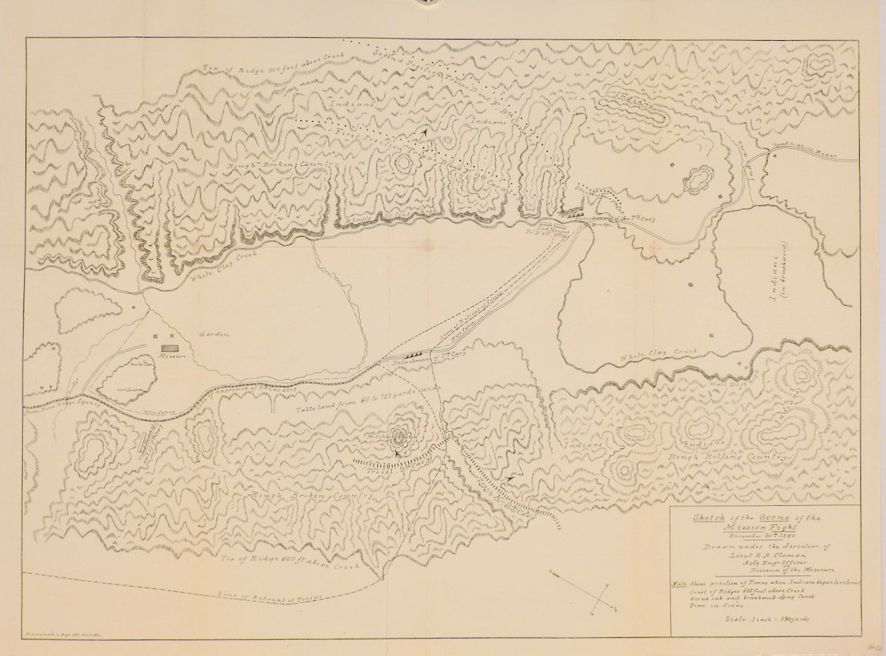
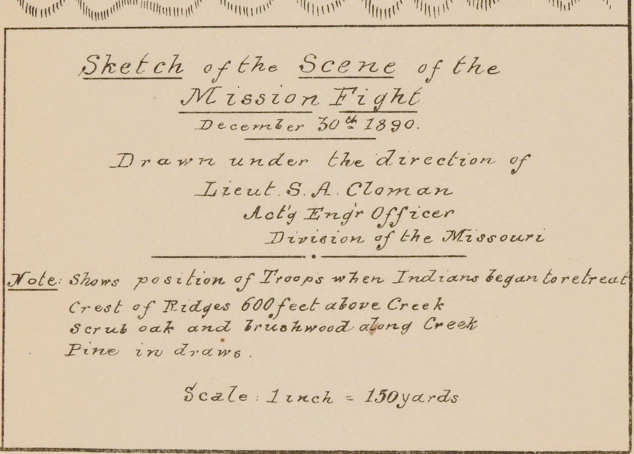
Battle of Wounded Knee] Sketch of the Scene of the Mission Fight December 30th 1890. Drawn under the direction of Lieut. S.A. Cloman . . . Division of the Missouri
Physical Description:1 map : uncolored ; 8 x 8 in
Publication Info: Washington, D.C.
Date:1891
Imprint:Washington, D.C. 1891
Notes:
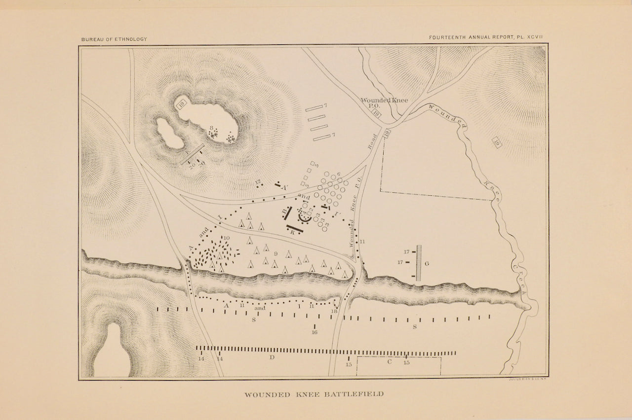
- Detailed map of the Battle Field during the Battle of Wounded Knee, showing the troop positions at the time the first shots were fired. The map shows the positions of mounted and unmounted troops, the Cavalry Camp, G Troop, Indian Scouts, and the names Wounded Knee Creek, Wounded Knee Road, the Porcupine x Medicine Root Road, and the cutoff to W.K. Road. The title block notes that the map was drawn by Pvt. James Hade. The Wounded Knee Massacre or Battle of Wounded Knee occurred on the eve of the Death of Chief Sitting Bull on December 15, 1890, during an attempted arrest. After Sitting Bull's death, 200 members of his Hunkpapa band, fearful of reprisals, fled Standing Rock to join Chief Spotted Elk (later to be known as "Big Foot") and his Miniconjou band at the Cheyenne River Indian Reservation. Spotted Elk and his band, along with 38 Hunkpapa, left the Cheyenne River Reservation on December 23, to journey to the Pine Ridge Indian Reservation to seek shelter with Red Cloud. The Battle / Massacre at Wounded Knee occurred on December 29, 1890, near Wounded Knee Creek on the Lakota Pine Ridge Indian Reservation in South Dakota. On the day before the Massacre, a detachment of the U.S. 7th Cavalry Regiment, commanded by Major Samuel M. Whitside, intercepted Spotted Elk's band of Miniconjou Lakota and 38 Hunkpapa Lakota near Porcupine Butte, and escorted them to Wounded Knee Creek, where they made camp. The remainder of the 7th Cavalry Regiment arrived, led by Colonel James W. Forsyth, and surrounded the encampment, supported by four Hotchkiss mountain guns. On the morning of December 29, the troops went into the camp to disarm the Lakota. One version of events claims that during the process of disarming the Lakota, a deaf tribesman named Black Coyote was reluctant to give up his rifle, claiming he had paid a lot for it. A scuffle over Black Coyote's rifle escalated and a shot was fired which resulted in the 7th Cavalry's opening fire indiscriminately from all sides, killing men, women, and children, as well as some of their own fellow soldiers. The Lakota warriors who still had weapons began shooting back at the attacking soldiers, who quickly suppressed the Lakota fire. The surviving Lakota fled, but U.S. cavalrymen pursued and killed many who were unarmed.
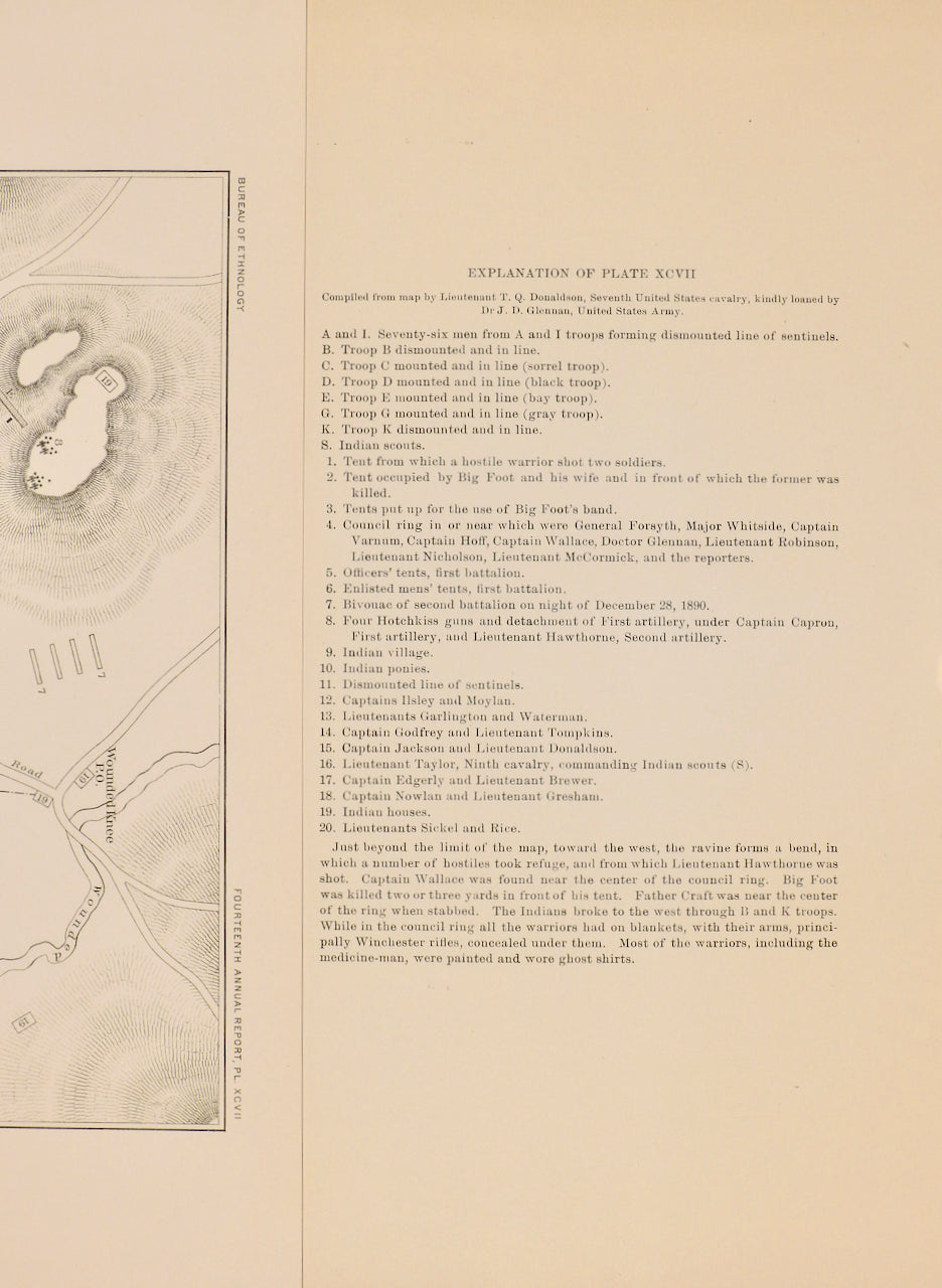
- Wounded Knee Battlefield. 14.7x20.5 cm plus margins. Plate xcvii from the 14th annual report of the Bureau of Ethnology. Neatly taped to the printed explanatory text sheet.
- Sketch of the Scene of the Mission Fight December 30th 1890. Drawn under the direction of Lieut. S.A. Cloman... Note: Shows position of Troops when Indians began to retreat.
The Drexel Mission Fight was an armed confrontation between Lakota warriors and the United States Army that took place on the Pine Ridge Indian Reservation in South Dakota on December 30, 1890, the day after the more famous Wounded Knee Massacre.
Sketch of the Scene of the Mission Fight December 30th 1890
Dimensions: 17 x 13 in (43 x 33 cm)
This is an uncolored map on a scale of 1 inch = 150 yards showing the various positions of the 7th and 9th Cavalry as well as the Indigenous warrior positions. Drawn under the direction of Lieutenant S.A. Cloman, Acting Engineer Officer of the Division of the Missouri, this map depicts the events of the Drexel Mission Fight, which took place a day after Wounded Knee on December 30th, 1890, 15 miles north of Pine Ridge where Lakota were purported to have burned the Drexel Mission.
This map also shows the wagon routes from Pine Ridge Agency to White River. The map names the (Drexel) Mission and garden and White Clay Creek, and shows the topography in great detail.